Industrial emissions are among the most difficult to measure. Across oil and gas operations, agriculture, and other industries, greenhouse gas emissions often come from small, scattered sources that are hard to enforce. Without continuous visibility, accountability weakens, and climate targets become harder to meet.
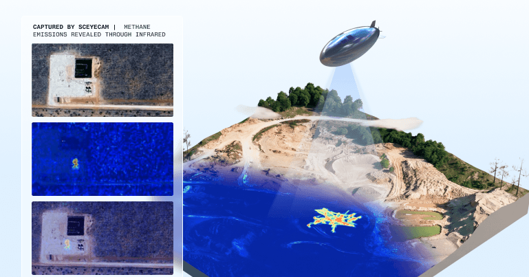
Sceye’s High-Altitude Platform Systems (HAPS) are changing that by providing real-time detection and continuous wide-angle monitoring from the stratosphere. This opens new possibilities for how governments, regulators, and industries can detect, quantify, and respond to pollution with greater speed, accuracy, and coverage than before.
Infrastructure at 65,000 feet
Most emissions monitoring today rely on snapshots. Satellites provide global coverage but revisit the same location only days or weeks apart. Aircraft, drones, and ground crews offer detail but with limited flight times or only during short, scheduled inspections. These approaches leave significant gaps, particularly when emissions are sporadic or short-lived.
Sceye operates from a fixed position approximately 65,000 feet above Earth. From this unique vantage point, our solar-powered HAPS can remain over an area for extended periods, delivering persistent observation across thousands of square miles.
This combination of endurance, coverage, and resolution enables Sceye to pinpoint individual emission sources down to the pixel.
World’s first real-time methane monitoring from the stratosphere
In 2024, Sceye achieved a global first: real-time detection and continuous wide-angle monitoring of methane emissions from the stratosphere, which identified specific emitters and quantified the rate of emissions.
In alignment with U.S. Environmental Protection Agency (EPA) and the New Mexico Environment Department (NMED) goals, Sceye conducted two missions over the Permian Basin, identifying leaks emitting tens of kilograms per hour, as well as “super emitters” releasing roughly 1,000 kilograms per hour, levels that have an outsized impact on near-term warming.
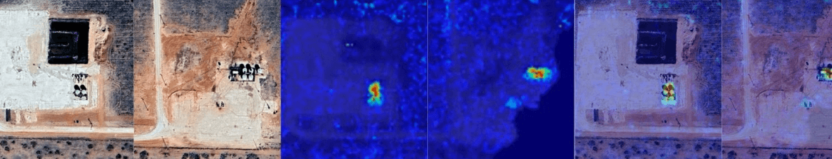
On these missions, Sceye deployed a custom-modified dual-sensor payload combining advanced shortwave infrared hyperspectral imaging with high-resolution optical cameras. From the stratosphere, this system enabled:
● High-resolution detection: Demonstrated ability for granular imaging at sub meter
precision, enabling unprecedented visibility from the stratosphere.
● Super-emitter capture: Identified multiple emitters of various sizes, including a rogue
source emitting ~1,000 kg/hr, or 10x the EPA threshold for a super emitter.
● Persistent wide-area coverage: Continuous surveillance across thousands of square
miles in the Permian Basin, vs LEO satellites, which typically scan days or weeks apart.
● Quantified specific emissions: Quantified specific methane emissions using custom,
advanced payloads with infrared and optical sensors, revealing both large and
previously undetected leaks.
● Operational proof of concept: Validated imaging and quantification from the
stratosphere, at a resolution, cadence, and coverage previously impossible.
This breakthrough capability allows regulators and operators to move beyond identifying methane plumes to pinpointing the exact source and rate of emissions—down to a specific well—within minutes rather than months.Read more in FastCo here.
This is just the beginning
Methane monitoring is just one example of what persistent observation from the stratosphere makes possible. The same capabilities that allow Sceye to detect emissions in real time also enable early wildfire detection, maritime and coastal monitoring, vegetation dynamics, volcanic plumes, geology, and more. Staying in place for extended periods allows our HAPS to identify change in real time to provide continuous situational awareness to better understand and respond to climate challenges.